Logistics and Resource Management using Drones provide real-time operational visibility across construction and infrastructure sites by continuously monitoring materials, machinery, and workforce movement. High-resolution aerial imagery combined with AI analytics enables accurate tracking of material flow, equipment utilization, and site congestion—transforming traditional logistics into a data-driven control system.
This drone-enabled management layer helps prevent material shortages and wastage, improves machinery productivity by identifying idle time, and optimizes site layout and workflow efficiency. By delivering objective, time-stamped insights, it supports smarter procurement planning, lean construction practices, and measurable cost savings while ensuring smoother project execution and improved resource accountability.
Workflow Optimization
Workflow Optimization using Drones
Overview
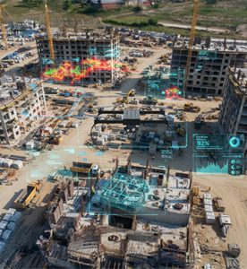
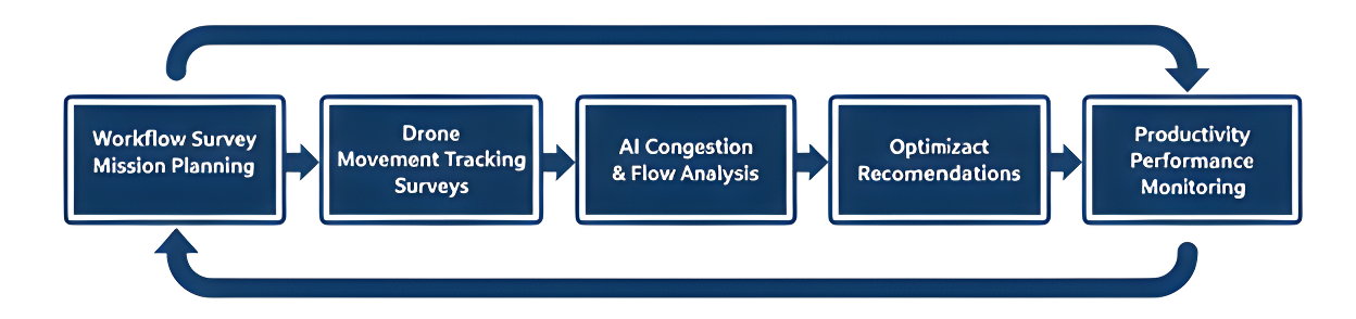
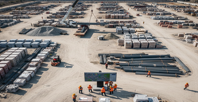
Workflow Optimization using Drones analyzes site layout, worker movement patterns, vehicle routes, and congestion zones using aerial imagery and AI-based motion analytics. This application identifies workflow bottlenecks, unsafe congestion points, and inefficient material flow paths that reduce productivity. The resulting insights enable layout redesign, route optimization, and manpower allocation strategies that significantly improve site efficiency and safety.
Process Flow
Reference Image
Relevant Outcomes / Deliverables
| Deliverable | Format | Usage |
|---|---|---|
| Congestion Heat Maps | GeoTIFF | Workflow redesign and bottleneck identification |
| Worker Movement Analytics | Productivity optimization and manpower planning | |
| Optimized Route Maps | SHP / PDF | Site planning and traffic flow improvement |
| Workflow Efficiency Report | PDF / CSV | Layout redesign and operational decision-making |
Achievable Accuracy
| Parameter | Typical Accuracy | Depends On |
|---|---|---|
| Movement Detection Accuracy | 88–95% | Camera angle, flight altitude, and AI model performance |
| Positional Accuracy | ±2–4 cm | RTK positioning and GNSS signal quality |
| Route / Congestion Mapping Accuracy | ±5–10 cm | Image resolution and motion analytics quality |
Key Advantages
- Improves site productivity and operational safety
- Reduces delays caused by congestion and poor routing
- Enhances manpower utilization and task allocation
- Improves site layout efficiency and material flow
- Supports lean construction and continuous process improvement
Compatible Drone Platforms
- Enterprise Mapping UAVs
- Compact AI Drones
- VTOL Survey UAVs
Supported Sensors / Payloads
- High-Resolution RGB Cameras
- AI Vision Modules
Industry Segments Benefited
- Construction
- Infrastructure
- Smart Cities
- Industrial Parks
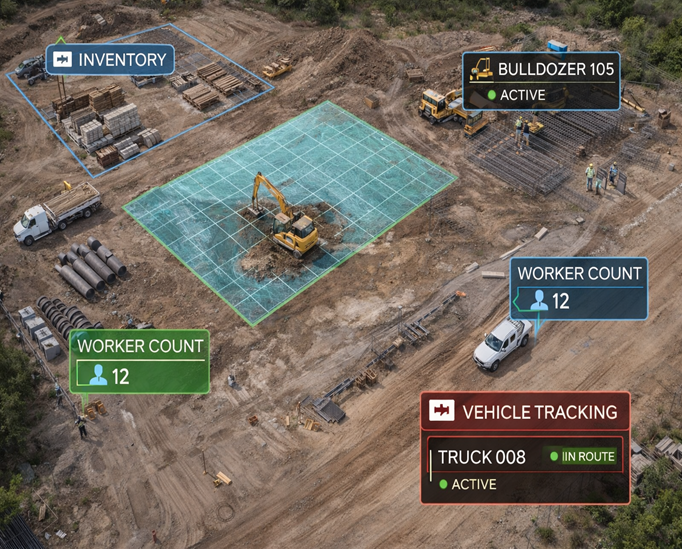
Equipment Monitoring
Equipment Monitoring using Drones
Overview
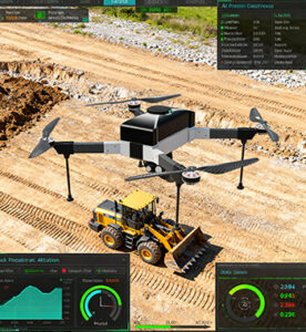
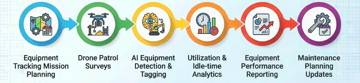
Equipment Monitoring using Drones provides aerial visibility of machinery location, utilization rates, idle time, and movement patterns across large construction and industrial sites. AI-powered object detection models automatically classify and track excavators, cranes, dumpers, loaders, and transport vehicles. This application improves asset utilization, reduces fuel wastage, and supports maintenance scheduling through data-driven operational insights.
Process Flow
Reference Image
Relevant Outcomes / Deliverables
| Deliverable | Format | Usage |
|---|---|---|
| Equipment Utilization Reports | PDF / CSV | Machinery productivity optimization |
| Idle Time Analytics | Fuel consumption and cost reduction | |
| Equipment Location Maps | GeoTIFF / SHP | Fleet movement tracking and coordination |
| Maintenance Insight Report | PDF / CSV | Supports predictive maintenance planning |
Achievable Accuracy
| Parameter | Typical Accuracy | Depends On |
|---|---|---|
| Detection Accuracy | 90–97% | AI model training and object visibility |
| Positional Accuracy | ±2–4 cm | RTK positioning and GNSS signal quality |
| Movement Tracking Accuracy | ±5–15 cm | Flight altitude, frame overlap, and model calibration |
Key Advantages
- Improves machinery productivity and operational efficiency
- Reduces fuel consumption and maintenance costs
- Helps prevent equipment misuse and unplanned downtime
- Enhances fleet coordination across large sites
- Enables predictive maintenance through usage insights
Compatible Drone Platforms
- Enterprise Surveillance UAVs
- Compact Mapping Drones
- VTOL Survey UAVs
Supported Sensors / Payloads
- Zoom RGB Cameras
- AI Vision Modules
- RTK GNSS
Industry Segments Benefited
- Construction
- Mining
- Infrastructure
- Oil & Gas
Material Tracking
Material Tracking using Drones
Overview
Material Tracking using Drones provides continuous visibility of construction materials from site entry to final utilization. High-resolution aerial mapping and AI-based material recognition enable real-time monitoring of material stockpiles, storage zones, and consumption patterns—preventing stockouts, pilferage, over-ordering, and wastage. This application establishes a digital material inventory layer that supports procurement planning, billing verification, and logistics coordination.
Process Flow
Reference Image
Relevant Outcomes / Deliverables
| Deliverable | Format | Usage |
|---|---|---|
| Stockpile Volume Reports | PDF / CSV | Material quantity verification |
| Material Location Maps | GeoTIFF / SHP | Storage layout and optimization |
| Consumption Trend Reports | Procurement forecasting and planning | |
| Material Audit Report | PDF / CSV | Billing validation and inventory reconciliation |
Achievable Accuracy
| Parameter | Typical Accuracy | Depends On |
|---|---|---|
| Volume Estimation Accuracy | ±3–5% | GSD, image overlap, and model quality |
| Positional Accuracy | ±2–4 cm | RTK positioning and GCP layout |
| Material Boundary Detection | ±5–10 cm | Image resolution and AI segmentation accuracy |
Key Advantages
- Prevents material shortages and stockouts
- Reduces wastage, pilferage, and over-ordering
- Improves billing accuracy and inventory transparency
- Enables data-driven procurement and logistics planning
- Enhances overall site organization and material control
Compatible Drone Platforms
- Mapping Quadcopters
- VTOL Long-Endurance UAVs
- Enterprise Survey Drones
Supported Sensors / Payloads
- High-Resolution RGB Cameras
- RTK GNSS Modules
Industry Segments Benefited
- Construction
- Infrastructure
- Mining
- Real Estate
- Smart Cities