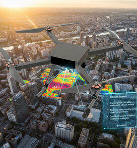

Urban Heat Island Analysis
As cities expand, rising surface and air temperatures create Urban Heat Islands (UHIs) — areas significantly warmer than their rural surroundings. Drone-based thermal imaging and environmental monitoring provide a precise, data-driven approach to study and mitigate these heat effects. By delivering real-time thermal maps, drones empower city planners, environmental scientists, and policymakers to design more sustainable and climate-resilient urban ecosystems.
Key Features
High-Resolution Thermal Imaging
Captures detailed surface temperature variations using advanced thermal sensors for accurate heat distribution mapping.
Real-Time Environmental Data Collection
Gathers live temperature, humidity, and radiation data to monitor heat patterns and climate behavior in dense urban areas.
Multi-Spectral & Infrared Sensing
Combines visible, near-infrared, and thermal imaging to analyze vegetation, infrastructure materials, and their impact on heat retention.
AI-Driven Data Analytics
Processes large thermal datasets through AI algorithms to identify heat hotspots and suggest targeted cooling interventions.
Urban Climate Mapping
Generates 2D and 3D temperature maps integrated with GIS platforms for advanced city-wide heat visualization.
Monitoring of Cooling Initiatives
Evaluates the effectiveness of green roofs, reflective pavements, and vegetation cover in reducing surface heat.
Autonomous Flight Operations
Enables consistent data collection across large urban areas using pre-programmed AI-assisted flight missions.
Support for Sustainable Urban Planning
Provides actionable insights for urban design, promoting better air quality, reduced energy demand, and improved livability.
Key Benefits
- City planning and zoning optimization
- Assessing vegetation cover and green infrastructure impact
- Identifying suitable areas for solar panel installations
- Evaluating water body effects on local microclimates
- Monitoring heat from pavements, buildings, and urban surfaces
- Supporting climate action and sustainability programs
- Generating temperature distribution reports for policy use