
Structural Inspections using Drones
Overview
Structural Inspections using Drones provide a safe, fast, and high-precision solution for close-range inspection of bridges, towers, cranes, chimneys, transmission structures, and high-rise buildings. Instead of deploying scaffolding, rope access teams, or heavy lifting equipment, UAVs equipped with zoom and oblique cameras capture ultra-high-resolution imagery of hard-to-reach components.
This application enables early detection of cracks, corrosion, joint misalignment, deformation, and material deterioration while significantly reducing inspection time, operational cost, and safety risks. The collected imagery establishes a digital condition baseline to support preventive maintenance planning and long-term asset life-cycle management.
Process Flow
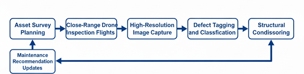
Reference Image

Relevant Outcomes / Deliverables
| Deliverable | Format | Usage |
|---|---|---|
| Close-Range Inspection Images | JPG / TIFF | Crack and corrosion analysis |
| Defect Mapping Report | Maintenance planning and prioritization | |
| 3D Structural Models | OBJ / SKP | Deformation and alignment review |
| Condition Assessment Report | Asset health documentation | |
| Inspection Videos | MP4 | Visual audit and compliance records |
Achievable Accuracy
| Parameter | Typical Accuracy | Depends On |
|---|---|---|
| Image Resolution | < 1 mm/pixel | Camera sensor quality and inspection distance |
| Positional Accuracy | ±2–4 cm | RTK positioning and flight stability |
Key Advantages
- Eliminates working-at-height safety risks
- Faster and more efficient inspection cycles
- Enables proactive and preventive maintenance
- High-resolution defect visibility
- Reduces operational downtime and inspection cost
Compatible Drone Platforms
- Compact Inspection UAVs
- Enterprise Quadcopters
- VTOL Long-Endurance UAVs
Supported Sensors / Payloads
- Zoom RGB Cameras
- Oblique Cameras
- RTK GNSS Modules
Industry Segments Benefited
- Infrastructure
- Power Utilities
- Oil & Gas
- Ports & Harbors
- Real Estate
- Smart Cities

