
3D Modelling and BIM Integration using Drones
Overview
This application involves using drones to capture high-density spatial data to create high-fidelity 3D Digital Twins of a project site. By integrating this real-world data into Building Information Modelling (BIM) software, project teams can overlay planned architectural designs onto the actual terrain. This ensures that the digital blueprint and the physical site are perfectly synchronised, enabling automated error detection, design validation, and seamless coordination before and during construction.
Process Flow
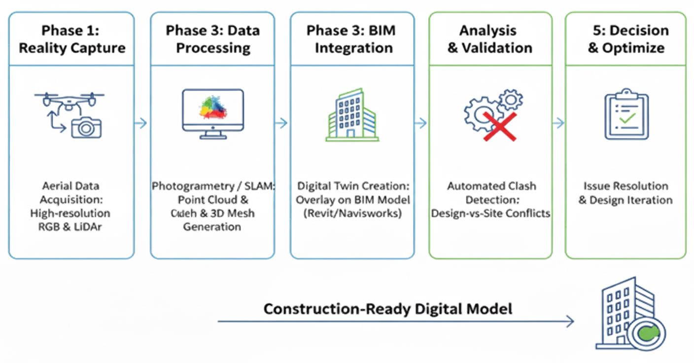
Reference Image
Relevant Outcomes / Deliverables
| Deliverable | Format | Usage |
|---|---|---|
| Orthomosaic Map | GeoTIFF | Provides a precise 2D base map for site planning and logistics layout |
| 3D Textured Mesh | OBJ / FBX / SKP | Facilitates stakeholder approvals through realistic virtual site walkthroughs |
| Contour Map | SHP / DXF / DWG | Integrated into CAD to define foundation elevations and grading requirements |
| Survey Report | PDF / CSV | Quantifies on-site material stockpiles for accurate cost and haulage estimation |
| Digital Terrain Model (DTM) | DEM / TIF / DXF | Used for precise earthwork cut-and-fill calculations and drainage design |
| BIM Overlay | NWD / RVT | Validates that the digital design aligns perfectly with real-world site constraints |
Achievable Accuracy
| Parameter | Typical Accuracy | Depends On |
|---|---|---|
| Absolute Horizontal Accuracy | 1–3 cm | Use of RTK/PPK GNSS or accurately surveyed Ground Control Points (GCPs) |
| Absolute Vertical Accuracy | 2–5 cm | Number and distribution of GCPs or LiDAR sensor precision |
Key Advantages
- Provides high-precision as-built reality capture
- Enables automated clash detection between planned designs and real-world site conditions
- Minimizes costly rework by identifying inconsistencies early
- Supports real-time design-to-site validation and coordination
Compatible Drone Platforms
- Enterprise Workhorse (Skywing 90)
- VTOL (Sentinel)
- Compact Professional Platforms
Supported Sensors / Payloads
- Photogrammetry (High-Resolution RGB Sensors)
- LiDAR (Light Detection and Ranging)
- Thermal Sensors
Industry Segments Benefited
- Civil Engineering & Infrastructure
- Energy & Utilities
- Real Estate & Land Development
- Mining & Quarrying
- Commercial Construction
- Oil & Gas
- Urban Planning