Safety and Risk Management using Drones provide a proactive, real-time safety intelligence layer across construction and industrial sites. By continuously monitoring site conditions, worker activity, and high-risk zones through automated aerial patrols, drones help identify potential hazards before they result in accidents, delays, or compliance violations.
This drone-enabled safety framework allows teams to detect unstable terrain, unsafe working practices, unauthorized access, and emergency situations in real time. Integrated thermal imaging, live surveillance feeds, and AI-based hazard detection models support faster emergency response, stronger regulatory compliance, and a measurable reduction in incident rates—creating safer, smarter, and more resilient project environments.
Emergency Response
Site Surveillance
Site Surveillance using Drones
Overview
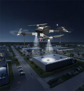
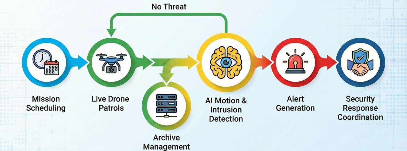
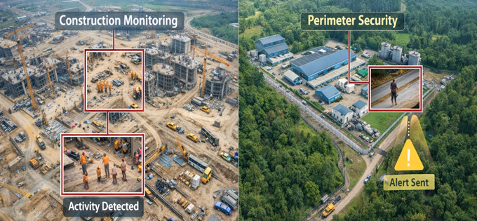
Site Surveillance using Drones delivers continuous live aerial video feeds for round-the-clock monitoring of large, complex, and remote project sites. UAVs equipped with stabilized zoom cameras, thermal sensors, and encrypted transmission systems enhance security enforcement by detecting unauthorized access, material theft, trespassing, perimeter breaches, and unsafe activities in real time.
This application significantly strengthens site security operations while reducing dependence on fixed CCTV infrastructure, manual patrols, and static surveillance systems—offering flexible, mobile, and scalable security coverage.
Process Flow
Reference Image
Relevant Outcomes / Deliverables
| Deliverable | Format | Usage |
|---|---|---|
| Live Video Feeds | RTSP / MP4 | Real-time security monitoring & recording |
| Intrusion Detection Logs | PDF / CSV | Incident documentation and evidence records |
| Patrol Reports | Security audits and compliance verification |
Achievable Accuracy
| Parameter | Typical Accuracy | Depends On |
|---|---|---|
| Detection Accuracy | 90–98% | Camera zoom capability & AI detection models |
| Positional Accuracy | ±2–5 cm | RTK positioning & flight stability |
Key Advantages
- 24/7 aerial surveillance and rapid response capability
- Reduces theft, trespassing, and perimeter breaches
- Enables instant incident detection and escalation
- Flexible and mobile security coverage
- Lower operational security costs compared to static systems
Compatible Drone Platforms
- Long-Endurance VTOL UAVs
- Tethered Surveillance Drones
- Enterprise Quadcopters
Supported Sensors / Payloads
- Optical Zoom RGB Cameras
- Thermal Cameras
- Encrypted Data Transmission Links
Industry Segments Benefited
- Infrastructure
- Mining
- Power Plants
- Industrial Parks
- Oil & Gas
Hazard Identification
Hazard Identification using Drones
Overview
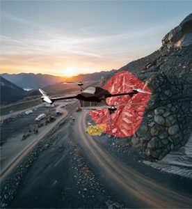
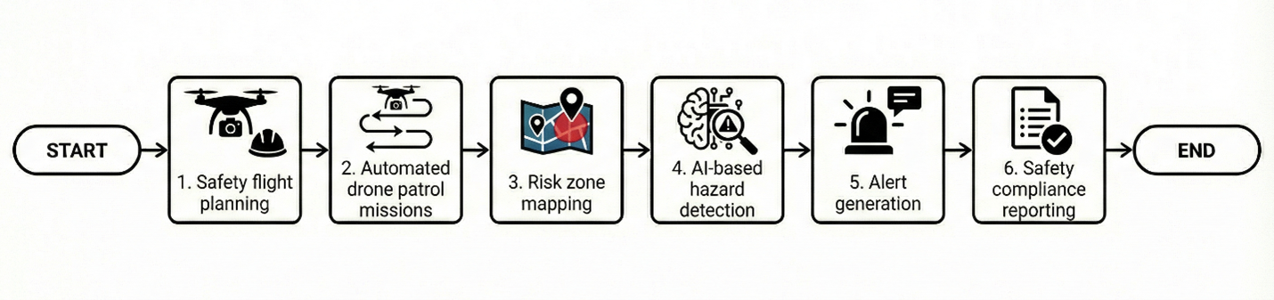
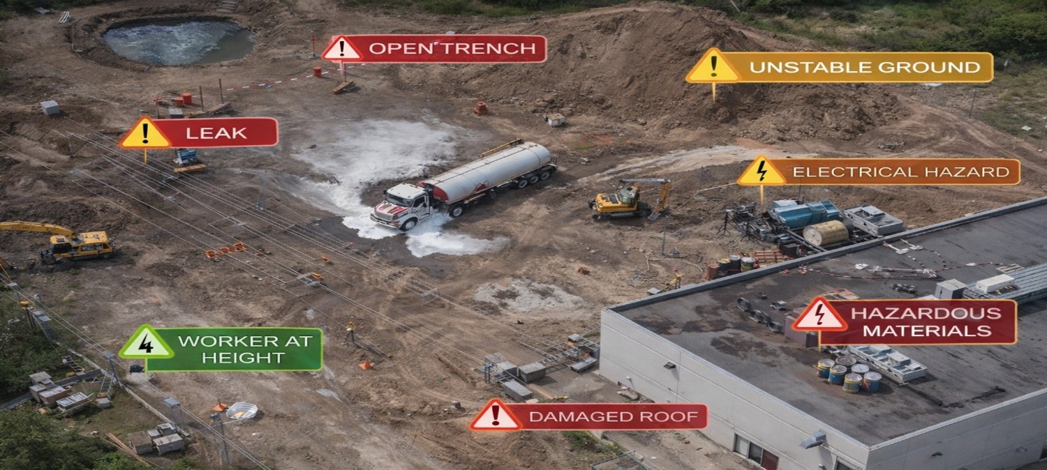
Hazard Identification using Drones provides continuous safety intelligence by monitoring unsafe zones, unstable terrain, excavation edges, material stockpiles, and active worker movement across project sites. High-resolution aerial data enables safety teams to proactively detect risks such as slope instability, open trenches, congested operational zones, falling hazards, and PPE non-compliance before they escalate into serious accidents.
This application creates a dynamic Safety Digital Twin of the site, enabling predictive risk modelling, intelligent safety zoning, and compliance documentation that significantly reduces incident rates while strengthening overall worker safety culture.
Process Flow
Reference Image
Relevant Outcomes / Deliverables
| Deliverable | Format | Usage |
|---|---|---|
| Hazard Zone Maps | GeoTIFF / SHP | Risk area demarcation and safety zoning |
| Safety Violation Reports | Compliance audits and documentation | |
| PPE Detection Logs | CSV / PDF | Workforce safety monitoring and tracking |
Achievable Accuracy
| Parameter | Typical Accuracy | Depends On |
|---|---|---|
| Positional Accuracy | ±2–4 cm | RTK positioning & Ground Control Point (GCP) density |
| Detection Precision | 90–96% | AI model quality, training dataset & site conditions |
Key Advantages
- Proactive accident prevention and hazard mitigation
- Improves regulatory and site safety compliance
- Enables predictive and data-driven risk planning
- Reduces insurance liabilities and legal exposure
- Creates structured digital safety audit trails
Compatible Drone Platforms
- Enterprise Surveillance UAVs
- VTOL Long-Endurance UAVs
- Compact Inspection Drones
Supported Sensors / Payloads
- High-Resolution RGB Cameras
- AI Vision Modules
- RTK GNSS Systems
Industry Segments Benefited
- Construction
- Infrastructure
- Mining
- Oil & Gas
- Smart Cities