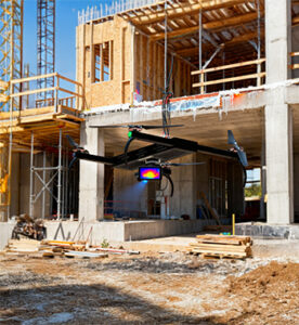
Inspection and Quality Control using Drones establishes a high-precision, non-contact monitoring layer that ensures structural integrity, workmanship quality, and compliance throughout construction and maintenance phases. By deploying UAVs equipped with high-resolution, zoom, and thermal sensors, project teams can inspect hard-to-reach structures, detect hidden defects, and verify build quality without interrupting site operations.
This drone-based inspection framework enables early identification of cracks, corrosion, misalignments, insulation failures, moisture ingress, and surface deformities. When combined with AI-powered defect detection models, it transforms manual inspections into a standardized, data-driven quality assurance system that improves safety, reduces rework, accelerates approvals, and extends asset life cycles—ensuring that every stage of construction meets design and regulatory standards.
Thermal Imaging
Thermal Imaging using Drones
Overview
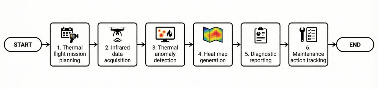
Thermal Imaging using Drones introduces non-contact temperature-based diagnostics for construction, infrastructure, and industrial maintenance activities. By capturing infrared radiation, thermal UAV payloads identify insulation failures, moisture ingress, concealed water leaks, overloaded electrical circuits, and energy loss points that remain invisible to the naked eye.
This application supports preventive maintenance programs by detecting overheating equipment, HVAC inefficiencies, solar panel defects, and hidden structural moisture—preventing failures before they escalate into costly repairs, downtime, or safety hazards.
Process Flow
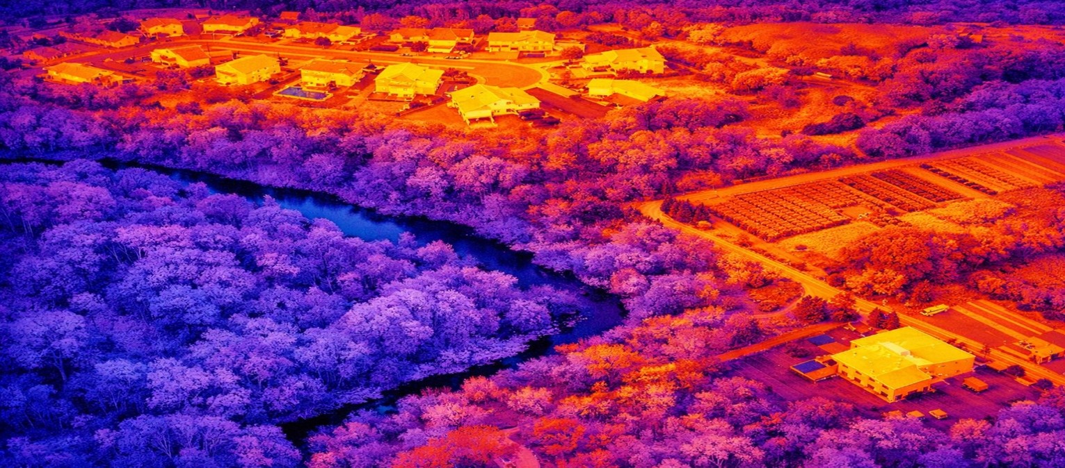
Reference Image
Relevant Outcomes / Deliverables
| Deliverable | Format | Usage |
|---|---|---|
| Thermal Heat Maps | Radiometric JPG / TIFF | Leak detection and hotspot identification |
| Electrical Hotspot Report | Preventive maintenance planning | |
| HVAC & Insulation Loss Maps | Energy efficiency and insulation audits |
Achievable Accuracy
| Parameter | Typical Accuracy | Depends On |
|---|---|---|
| Temperature Sensitivity | ±0.05–0.1°C | Sensor grade, emissivity settings & calibration |
| Positional Accuracy | ±2–5 cm | Flight stability & GNSS/RTK positioning |
Key Advantages
- Non-contact and safe diagnostics
- Early failure and overheating detection
- Improves safety and energy efficiency
- Reduces unplanned downtime and repair costs
- Supports ESG and sustainability compliance
Compatible Drone Platforms
- Enterprise Thermal UAVs
- VTOL Survey UAVs
- Compact Inspection Drones
Supported Sensors / Payloads
- Thermal Infrared Cameras
- RGB-Thermal Dual Sensors
Industry Segments Benefited
- Construction
- Power Utilities
- Renewable Energy
- Smart Buildings
- Oil & Gas
Defect Detection
Defect Detection using Drones
Overview
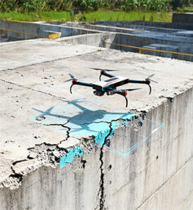
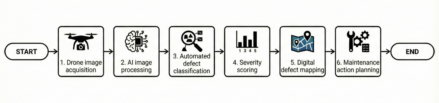
Defect Detection using Drones combines UAV-based high-resolution data acquisition with AI-powered image analytics to automatically identify cracks, spalling, corrosion, uneven surfaces, coating failures, and material degradation. Advanced machine learning models process thousands of inspection images to detect and classify potential defects with greater consistency, objectivity, and speed compared to manual inspections.
This application enables large-scale asset condition screening, structured defect classification, and creation of digital defect inventories that support proactive maintenance planning and long-term lifecycle asset management.
Process Flow
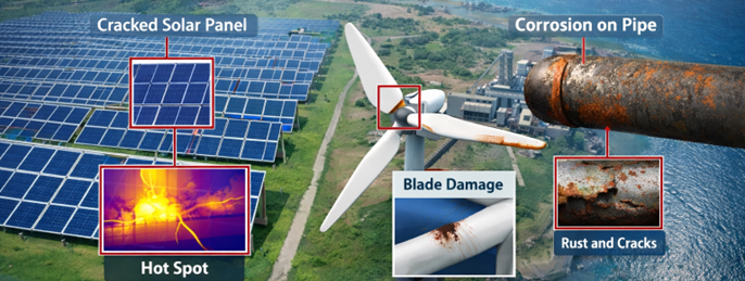
Reference Image
Relevant Outcomes / Deliverables
| Deliverable | Format | Usage |
|---|---|---|
| AI Defect Maps | SHP / GeoTIFF | Geospatial defect location tracking |
| Defect Inventory Database | CSV / PDF | Asset condition and maintenance records |
| Severity Ranking Report | Repair prioritization and budgeting |
Achievable Accuracy
| Parameter | Typical Accuracy | Depends On |
|---|---|---|
| Detection Precision | 90–98% | AI model training quality & dataset diversity |
| Positional Accuracy | ±2–4 cm | RTK positioning & Ground Control Points (GCPs) |
Key Advantages
- Automated and scalable defect identification
- Objective, repeatable, and data-driven inspections
- Faster large-area and vertical asset assessments
- Enables predictive and condition-based maintenance
- Creates a structured digital audit trail
Compatible Drone Platforms
- Skywing90
- SentinalVTOL
- Compact Enterprise UAVs
Supported Sensors / Payloads
- High-Resolution RGB Cameras
- Optical Zoom Cameras
- RTK GNSS Modules
Industry Segments Benefited
- Infrastructure
- Power Utilities
- Transportation
- Real Estate
- Smart Cities
- Oil & Gas
Structural Inspections
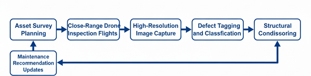
Structural Inspections using Drones
Overview
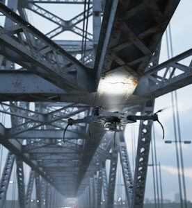
Structural Inspections using Drones provide a safe, fast, and high-precision solution for close-range inspection of bridges, towers, cranes, chimneys, transmission structures, and high-rise buildings. Instead of deploying scaffolding, rope access teams, or heavy lifting equipment, UAVs equipped with zoom and oblique cameras capture ultra-high-resolution imagery of hard-to-reach components.
This application enables early detection of cracks, corrosion, joint misalignment, deformation, and material deterioration while significantly reducing inspection time, operational cost, and safety risks. The collected imagery establishes a digital condition baseline to support preventive maintenance planning and long-term asset life-cycle management.
Process Flow
Reference Image

Relevant Outcomes / Deliverables
| Deliverable | Format | Usage |
|---|---|---|
| Close-Range Inspection Images | JPG / TIFF | Crack and corrosion analysis |
| Defect Mapping Report | Maintenance planning and prioritization | |
| 3D Structural Models | OBJ / SKP | Deformation and alignment review |
| Condition Assessment Report | Asset health documentation | |
| Inspection Videos | MP4 | Visual audit and compliance records |
Achievable Accuracy
| Parameter | Typical Accuracy | Depends On |
|---|---|---|
| Image Resolution | < 1 mm/pixel | Camera sensor quality and inspection distance |
| Positional Accuracy | ±2–4 cm | RTK positioning and flight stability |
Key Advantages
- Eliminates working-at-height safety risks
- Faster and more efficient inspection cycles
- Enables proactive and preventive maintenance
- High-resolution defect visibility
- Reduces operational downtime and inspection cost
Compatible Drone Platforms
- Compact Inspection UAVs
- Enterprise Quadcopters
- VTOL Long-Endurance UAVs
Supported Sensors / Payloads
- Zoom RGB Cameras
- Oblique Cameras
- RTK GNSS Modules
Industry Segments Benefited
- Infrastructure
- Power Utilities
- Oil & Gas
- Ports & Harbors
- Real Estate
- Smart Cities