Urban Planning & Smart City Industry
Cities are evolving faster than ever, demanding intelligent systems that make them sustainable, efficient, and resilient. Traditional urban planning methods struggle to keep up with rapid infrastructure expansion, environmental challenges, and population growth.
Drones for Urban Planning and Smart Cities are revolutionizing how governments, architects, and planners visualize, design, and monitor urban environments. These aerial systems deliver real-time data, high-resolution mapping, and 3D modeling that empower cities to make informed decisions for smarter growth.
At AKSI Group, our drone technologies support the entire lifecycle of urban development — from surveying and construction monitoring to traffic analytics and public safety. With integrated sensors, AI-driven analytics, and automated data processing, we enable authorities to plan better, respond faster, and build smarter cities for the future.
Key Features
High-Precision Aerial Mapping
Captures ultra-high-resolution geospatial data for accurate land surveys,
construction planning, and infrastructure assessment.
Traffic & Infrastructure Monitoring
Provides live data for managing congestion, road maintenance, and
infrastructure health using real-time analytics.
Environmental & Air Quality Assessment
Monitors pollution levels, vegetation health, and environmental impact
for informed urban sustainability initiatives.
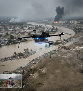
Disaster Management & Public Safety
Supports emergency teams with rapid aerial surveillance during floods,
fires, and other urban crises for faster response.
Smart Data Integration
Seamlessly integrates with GIS platforms, IoT systems, and smart city
dashboards for comprehensive decision-making.
Autonomous Mission Planning
AI-driven flight paths ensure consistent, safe, and repeatable operations
across urban environments.
Cost-Efficient City Management
Reduces manpower and operational costs in inspections, mapping, and
urban data collection.
Sustainable Urban Development
Enables eco-friendly city planning by promoting efficient resource usage
and minimizing environmental impact.
Key Benefits
- Smart city planning and infrastructure mapping
- Urban land-use and zoning analysis
- Traffic and mobility monitoring
- Construction and project compliance auditing
- Environmental and disaster management
- City asset and public safety surveillance